


Grain and livestock producers are keeping close tabs on rainfall amounts during a dry spring.
Environment Canada reports only three millimetres of rain fell at the Saskatoon airport, but areas around the city picked up as much as 15 millimetres, or just over half-an-inch.
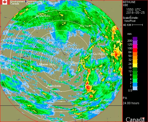
Doppler radar images indicate the most severe thunderstorms were in eastern Saskatchewan on Thursday. Meteorologist John Paul Cragg says there were heavier pockets of rain west of Weyburn all the way up to Fort Qu’appelle, as well as another area north and south of Yorkton. These storms cells generated heavy downpours and even hail.
“The area we got hail in is seeded to wheat,” says Kevin Hrushka, who farms in the Esterhazy area, 80 kilometres southeast of Yorkton. “It’s just emerging now and I think it will rebound quite well.”
Hrushka says the drier soil will soak up the moisture.
“During the wet years, you would get two-tenths of an inch of rain and it would seem like you had an inch. Now, the land is absorbing it quite well. It was getting dry.”
Northeast Saskatchewan received the most general rain. Melfort had 29 millimetres and Hudson Bay 22 millimetres. Other official totals include Melville (24mm), Vibank (18mm), Weyburn (14mm), Regina (11mm), Nipawin (6mm) and Prince Albert (1mm).
Cragg notes rainfall in the Prince Albert area was variable, with some locations north of the city picking up between 4 and 8 millimetres on Thursday.